Driving through this country is a lesson in history by itself. The Oregon Trail ran through here. From the diaries of those emigrants, the area didn’t look too much different than today, except for the current lack of trees. Settlers needed wood for structures and fuel. If they followed a river, though, they had water. Even today, you’ll be astonished by the lush agricultural fields growing near a water source, surrounded by stark hills.
The rivers are fed by the various mountain ranges on the horizons. Many flow well year-round due to snow melt. Others are tributaries of the mighty Columbia River, which begins its thousand-plus miles journey in Canada. Without water, the ranches around you would not exist. Without trading routes, the settlers wouldn’t have homesteaded these ranches.
The modern two-lane roads your travel often mark the original paths used by Native Americans for thousands of years to follow their hunting and gathering seasons, and later, by settlers getting goods to market. If you pause on a wayside and squint, you can easily imagine what it looked like 15,000 years ago with roaming tribes, or 150 years ago when emigrant land claims changed the country.
(See Part 1, Clarno Palisades Unit, here.)
(See Part 2, Sheep Rock Unit, here.)
Part 3 – Painted Hills Unit
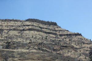
 You’ll notice a distinctive thick reddish layer of rock that seems to top most hills, steppes, and ridges as you drive through this region. That’s the Columbia River Basalt Group from floods of magma that occurred through five major volcanic eruptions 6 to 17.5 million years ago. In some places, one layer is twisted and heaved due to plate tectonics and continental drift, and a flat horizontal layer appears on top of it. Cool stuff! It covers a total area a smidge smaller than the state of Kansas – but in this case, it blankets parts of Oregon, Washington, Idaho and Nevada.
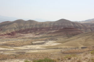
We hit Painted Hills on our way home, and some might say we saved the best for last. Drive off the main road for a bit until it turns to gravel, take a turn, and BOOM. I mused aloud that various sci-fi movie directors must have used these configurations as inspiration for their sets of other planets. All that was missing was a second sun!
 You might think of sand dunes at first, and you aren’t far from wrong in their origin 30 to 39 million years ago. Tan and red, orange and green, spots of black – they appear to change, depending on the moisture and time of day. It was a clear day, but doesn’t it look like there are cloud shadows on their faces? I’d love to see it in the spring, carpeted by wildflowers.
A tip: Visitors appear split on the best time of day or year to see these hills. We were there at midday and awe-struck. I’ve heard it’s even better when the hills are wet. Or with a rising or setting sun. It’s easy to imagine how that would alter the landscape. On some marked paths, you can get close to the layers. These hills are fragile, so postings to stay on trails are there for a reason.
Another tip: The facilities and lush, tree-shaded picnic area are the first left on the park’s gravel road. You’ll be more comfortable up on top of the overlook (and hiking) if you stop there first. Many short, easy hikes to different vantage points are available, as are short drives along the rough, gravel road. Some areas may not be easily passable after a good rain.
Like so many of our National Parks and Monuments, this widespread hidden gem takes time to get to and time to appreciate. Take that time. Enjoy the hikes. Stop to look up and sideways, not just at your carefully stepping feet. Linger. You’ll be glad you did!
What are some of your favorite outdoor national treasures? I’m well on my way to seeing one in each of the 50 states – and you?
